

Day surveillance with 1080 and 4k view
₹2,00,000.00 (excluding GST)
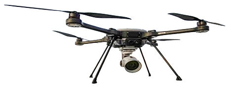
This Survey & Mapping Drone is a high-precision UAV designed for daytime aerial surveillance, mapping, and inspection tasks. Equipped with 1080p HD and 4K cameras, it captures sharp, detailed imagery and video for professional-grade surveys and real-time monitoring. The drone features stable flight control, GPS navigation, and intelligent flight modes, allowing accurate mapping, area coverage, and waypoint planning. Lightweight and portable, it is ideal for agriculture, construction, environmental monitoring, security surveillance, and land surveying. With long flight time, easy operation, and reliable performance, this drone ensures efficient data collection, enhanced situational awareness, and improved decision-making for professionals.
Related products

